
By Meteorologist, Liz Walsh – Met Éireann
After a period of quieter more slowly evolving weather earlier this month, our weather pattern is looking decidedly more generally changeable and at times very unsettled through the rest of October. As is often the case, this is largely in response to a strengthening of the Polar Front Jet Stream. The Jet Stream is identified as a zone of fast moving air high up in the atmosphere and it is responsible for driving and developing low pressure systems across the Atlantic towards our shores.
The strengthening of the Jet Stream is not unusual at this time of year as the temperature gradient between the tropics and the poles increases in response to the shorter daylight hours as we head into the winter months. The greater the difference in temperature, the stronger the Jet Stream becomes. This goes some way in explaining why we get most of our storms during the winter half of the year as opposed to the summer, although as we have seen recently with Storm Ellen and Francis, storms can and do happen at any time of the year!
How and where low pressure systems interact with the Jet Stream often determines whether a low pressure system will deepen or fill which then determines how impactful the wind and rain associated with that low pressure system will be.

Over the coming week, the Jet Stream is expected to help deepen areas of low pressure and direct them generally between Ireland and Iceland. Associated Atlantic frontal systems will cross the country resulting in successive spells of wet and windy, potentially stormy, weather, especially this weekend and on into early next week.
On Friday, an Atlantic low pressure system is expected to engage with the Jet Stream and rapidly deepen. The low itself is expected to track between Iceland and Ireland but the associated active frontal system will cross the country on Friday night and Saturday morning resulting in a period of very strong winds and heavy rain.
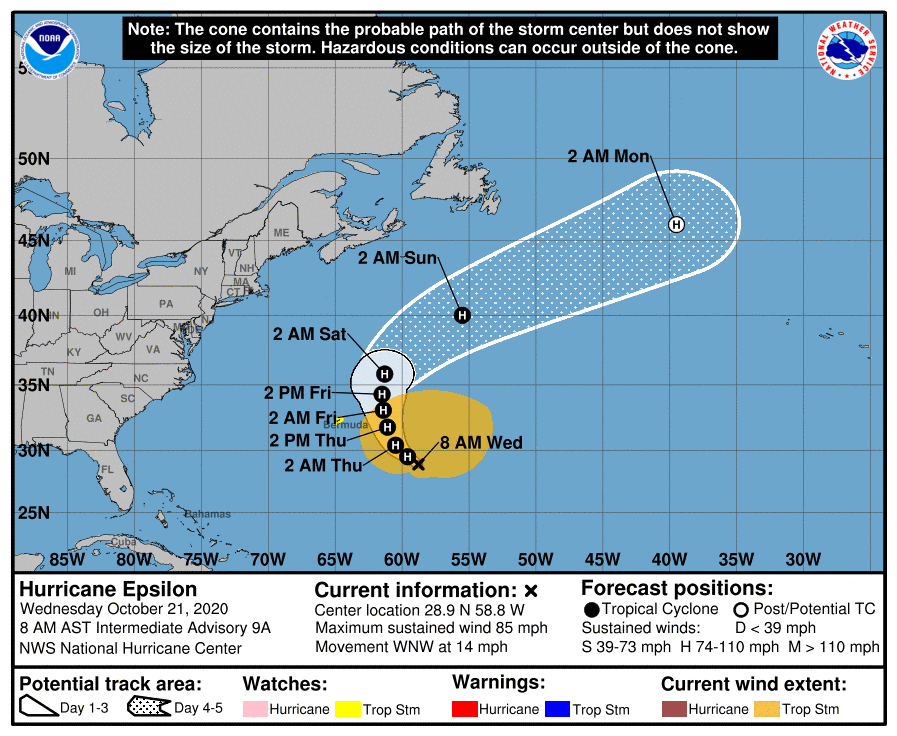
The next Atlantic low pressure system that will affect Ireland after Saturday, will be early next week and that low pressure system will likely contain the remnants of Epsilon, currently a category 1 Hurricane which is expected to curve northeastwards to the east of Bermuda this weekend. As mentioned in one of our meteorologist commentaries from last month, (see “The 2020 Hurricane Season so far” meteorologist commentary) we passed the peak of Atlantic Hurricane Season quite a while ago. In that commentary, it was also mentioned that: “The delayed warming of the Atlantic Ocean forces the location of extra-tropical transitioning storms northward late in the season so here in Ireland, we are more likely to see the remnants of these storms influencing our weather over the coming weeks and months.” And looking at the current set-up in the Atlantic right now, we can see that situation appears to be developing.
How Epsilon will interact with the Jet Stream is still uncertain at this stage, but certainly the current guidance across multiple models is suggesting a very deep low will be positioned to the northwest of Ireland in the north Atlantic early next week. This is likely to again bring a period of strong winds and heavy rain to our shores. How strong the winds will be will be dependent on the depth, location and track of the ex-Epsilon low. Whatever the case, Epsilon will no longer be a hurricane at that stage as it will have transitioned to mid-latitude low.
What happens to a hurricane structurally when it transitions?
- When a hurricane or tropical system moves up into the higher latitudes, the strong upper level winds (jet stream) cause the storm to speed up.
- At the same time, the increase in the wind speed in the upper air almost literally chops off the upper part of the hurricane and sweeps it away
- The hurricane is also starting to move over cooler water so its fuel source is depleting from below.
- Basically the hurricane structure gets destroyed from above and below.
- While the maximum wind often decreases, the wind field spreads out, so the overall impact of high winds actually increases due to the expansion of the wind field. So even though the winds may not be quite as strong as they were when the system was a hurricane, there is a wider area of potential for damage due to high winds owing to the expanded wind field.
Want to get €5, absolutely free? Sign up to the ‘Smart’ Debit Card – Curve today, and earn a fiver on us! Find out more here.